Knife River Villages
History books and historical sites commemorating Hidatsa and Mandan sites are often at odds about their spelling and meaning, which is often so confusing and inconsistent that even native speakers cannot figure out the intended pronunciation.
For example, the name of the last large Mandan village is given in different publications as Matootonha, Mitutanka, Mitutahank, and Mih-tutta-hang-kusch. The inhabitants of the southernmost Hidatsa village have been called Ahnahaways, Souliers, Wattasoons, and Mahawha.
Instead of picking up the phone and consulting with native speakers of Hidatsa and Mandan, many authors still prefer to compare the hard-to-decipher spellings in the Lewis and Clark journals or Prince Maximilian’s diaries before settling on the spelling that seems more “authentic.”
This article is the first in the series that will attempt to shed light on origin of the wildly differing variants of the Mandan and Hidatsa village names and then provide the corrected names in the most commonly used orthographies in both languages. The first article will focus on the five Knife River villages, made famous by the paintings of George Catlin and Karl Bodmer, and the writings of Prince Maximilian, and the explorers Meriwether Lewis and William Clark.
Historical background
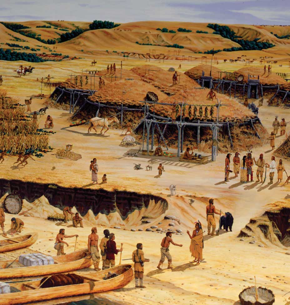
The 1782 smallpox epidemic, which decimated the Mandan and Hidatsa populations, was followed by more than a decade of turmoil and frequent dislocation. The seven to nine Mandan villages in the Heart River region around the present-day cities of Bismarck and Mandan had lost too many inhabitants to survive in the face of mounting pressure from the nomadic Sioux. Finally, the survivors of the Heart River villages moved and consolidated into two villages immediately to the south of the three Hidatsa villages around the confluence of the Knife River near the present-day town of Stanton.
The Five Villages, or Awadí Gihxú in Hidatsa and Mííti Kixų́h in Mandan, were located in a string along the Knife River (Hid: Mé’charu’aashi; Man: Mááhi Pasą́h) and the Missouri River (Hid: Awáàdhish; Man: Máátah). The three villages in the north were Hidatsa and the two in the south Mandan. The villages at the two ends were much larger than the three villages between them
Hidatsa villages
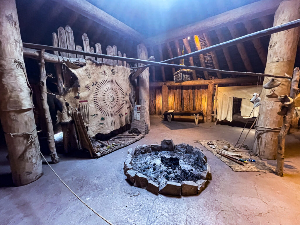
The northernmost Hidatsa village lies on the north bank of the Knife River. The village site has been preserved at the Knife River Indian Villages National Historic Site. The Hidatsa name of this village is simply Hiraacá, or Hiraacá Idawadí, Hidatsa Their-Village. According the tradition, the village used to be called Mirahací Awadísh, Willow Village, but a medicine man who came up from the Missouri called it Hiraacá, as the village, its inhabitants, and their descendants are still called now. Many old-time Hidatsas have claimed that Hiraacá means Willow People, but the etymology is no longer transparent.
In Mandan the northernmost Hidatsa village was called Minítaari Óxte’, Big Hidatsa, and the inhabitants Minítaari,Crossing-Water people. The village was also known as Minítaari Tamííti, Hidatsas Their-Village. Lewis and Clark first learned about the Hidatsa from their Mandan hosts and inadvertently introduced the Mandan name into English as Minnetaree.
The next Hidatsa village, or Awadixáá, lies on the south side of the Knife River, about a mile south from Hiraacá, or the Big Hidatsa, also at the Knife River Indian Villages National Historic Site. The village consists of two parts. The first part was abandoned after the smallpox epidemic of 1782, when the villagers built a new village next to the old one. In Hidatsa, the old abandoned half of the village is referred to as Awadixáá Xi’éè, or Old Awadixaa.
Both the Hidatsa and Mandan speakers claimed that the Hidatsa name Awadixáá is a corruption of the Mandan name Mííti Xááre, which means Spread-Out Village, referring to the lodges that were scattered or spaced out comfortably far from each other. Awadí in Hidatsa and mííti in Mandan both mean ‘village.’ To an untrained ear, the Mandan word xááre, sometimes shortened to xáá, spread out, apart, sounds superficially like the Hidatsa word xáá, raised, drawn up. At some point the mixed name got stuck and the village became known as the Elevated Lodges, or Elevated Village. Parallel historical forms in Hidatsa include Awadixáhi, Pulled-Up Lodges, and Awadixaa’ihbú, Elevated Lodges On The Hill.
The correct translation of the Mandan Mííti Xááre into Hidatsa would be Adi’éèchi, Spread-Out Lodges, a form that never caught on.
Although the inhabitants of Hiraacá and Awadixáá had different origin stories, they were considered the same people both by the Mandan and the early travelers, such as Lewis and Clark. In fact, Crows Heart referred to Awadixáá as the “suburb” of Hiraacá. Lewis and Clark referred to the inhabitants of the smaller village with the Mandan words as “the little village of the Menitarras” and the villagers as “Minnetarees Metaharta.”
Awadixáá has become famous for being the home of Bird Woman (Hid: Cagáàgawia; Man: Mááneksuk Mííhe).
The last Hidatsa village and also its inhabitants were known as Awaxá’wi, which means ‘jagged, sharp-pointed land.’ The name has often been translated into English as Mountain Village. In fact, the Mandan translation of the name, Maxáá Mííti, also means Mountain Village. The historical Awaxá’wi villages was destroyed when the town of Stanton was built on top of it. Only one earth-lodge depression remains, right next the Mercer County Courthouse.
Although the Awaxa’wi shared a similar origin story with the villagers of Hiraacá, they considered themselves a separate nation from the other two Hidatsa villages. They had their own dialect and were noted for the hairstyle, which resembled mountain ridges.
The Awaxa’wi have been variously labeled and misspelled as Ahnahaways, Arwacahwas, Mahawha (from Mandan maxááxa mountains), Wattasoons, and Souliers (from the French word for shoes after chief Idahbashibísha, or Black Moccasins, of the Awaxa’wi).
Mandan villages
During the time of Lewis and Clark there were two Mandan villages, one on the east bank of the Missouri and one on the west bank.
The west-bank village was inhabited mostly by the Nuu’etaare (or Nuu’etaa) Mandans, but there were also survivors from the defunct bands of Istoope (Tattooed Faces) and Awikaxa. The village itself was called Mííti Ų́’tahą’k, (in fast speech Míítų’tahą’k), or East Village. Although the East Village lied to the west of the other Mandan village at the time of Lewis and Clark, it was still called as such because the denizens of the village had brought the name with them from an earlier location near the Heart River (Man: Nátka Pasą́h; Hid: Naada’áàshi). The Hidatsa called the village Awadiráàdaga, Last Village.
In 1822, the villagers moved several miles downriver to a new location that offered better protection from the enemy. As before, the new village continued to be called East Village, or Míítų’tahą’k. This is the location that was made famous all over the world by the paintings of George Catlin and Karl Bodmer. The last location of the East Village is preserved at Fort Clark State Historic Site between Stanton and Washburn.
Before 1822, the Nuuptaare (or Nuuptaa) band of Mandans made its village on the east bank of the Missouri. It was simply called Núúptaa Tamííti, Nuuptaa Their-Village. No trace of this village site remains after the location was obliterated by the shifts in the course of the Missouri River.
After the East Village Mandans vacated their previous village site in 1822 and moved to Fort Clark, the Nuuptaare also decided to abandon their old east-bank village and move into the old Nuu’etaa village across the river. The name of the new Nuuptaa village was referred to as Awa’ihbawadí, or Clifftop Lodges, by the Hidatsa.
No trace remains of the original East Village that later became the Nuuptaa Village. In the 1950, the site was turned into a gravel pit and a power plant was built on top of it in the 1960s.
ąą́įį́ųų́ų̀ɛɛ́ɛ̀ Ą́Ę́Į́Ǫ́Ų́ ĄĘĮǪŲ
xxx